Fort Congaree II - What can we find today?
Geophysical survey
| "Geophysical
survey is used to create maps of subsurface archaeological features.
Features are the non-portable part of the archaeological record,
whether standing structures or traces of human activities left in the
soil. Geophysical instruments can detect buried features when their
physical properties contrast measurably with their surroundings. In
some cases individual artifacts, especially metal, may be detected as
well. Readings taken in a systematic pattern become a data set that can
be rendered as image maps. Survey results can be used to guide
excavation and to give archaeologists insight into the patterning of
non-excavated parts of the site. Unlike other archaeological methods,
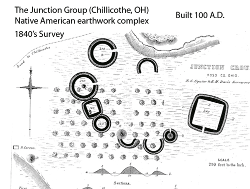
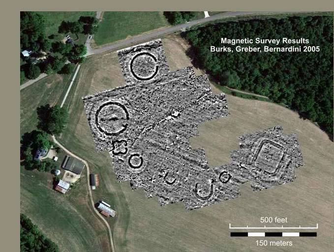
geophysical survey is neither invasive nor destructive" - Wikipedia With documentation in hand covering the construction details of Fort Congaree II, one obvious geophysical target feature would be the 1 to 2 meter deep ditch that was built around the outside of the fort. The plow zone is less than 1 meter deep so the bottom of the ditch should be detectable. The stone foundation of the cellar house within the fort may be the second best target. Given the 5 archival sources we have for the fort's location, we can narrow the search area to, we believe, within 40 meters (130 feet) of the fort. A magnometer/gradiometer would be a good instrument to find these target features. Below is a good example of this technology at work. Despite almost 200 years of plowing, the technology revealed crystal-clear outlines of a 2000 year-old Native American complex. The circular earthworks are probably similar in size and depth to the ditch around Fort Congaree II. |
The above animation shows how the surface features of the Indian complex have disappeared since the 1840's survey but today's magnetic readings from 1 meter deep show amazing details. Below is this magnetic mapping. |
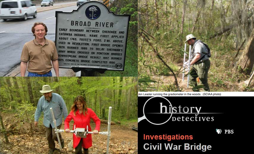
As well as a gradiometer survey, a GPR (Ground Penetrating Radar) survey could also detect fort features like the rock chimneys, rock cellar walls, and possibly the ditch. A metal detector survey could be performed to locate areas with high counts of iron hits. Below: In 2009, Dr. Jon Leader (South Carolina State Archaeologist) uses a gradiometer (with History Detective: Elise luray) to find the locations of a lost Confederate bridge and also the nearby 1865 Union Army's pontoon bridge crossing site. Similar to the archival research completed on the Fort Congaree II location, David Brinkman's research of these lost Civil War sites is what narrowed the search area for the geophysical survey. The 2009 project was featured on the PBS show: History Detectives. View the episode here. |
Excavation and data recovery
After the geophysical survey and data interpretation by a trained professional like Dr. Jon Leader, further steps can be taken to determine any excavation work. This could involve small test pits and some 1 meter square pits. Excavations just north of this area (in the Granby dig) and excavations just south (in Saxe Gotha in 2000), show artifacts down as low as .7 meters. If a Fort's ditch is detected in the geophysical survey, it could be useful to excavate along the ditch location to record a profile of the filled ditch. Digging would also be desired over a suspected cellar or chimney (which may have been detected by the magnetic or GPR survey). Other pits locations may be selected by the iron hit results of a metal detector survey. 18th century British documentation shows that 50,000 nails were purchased for the construction of the fort. It also mentions that locks were purchased which were probably for the powder magazine. We would also expect to find some personal items like glass bottle fragments and tobacco items (pipe stems and pipe bowl pieces). Military type items may also be found. |