Sarah Friday and her Granby drawing, and a modern day overlay
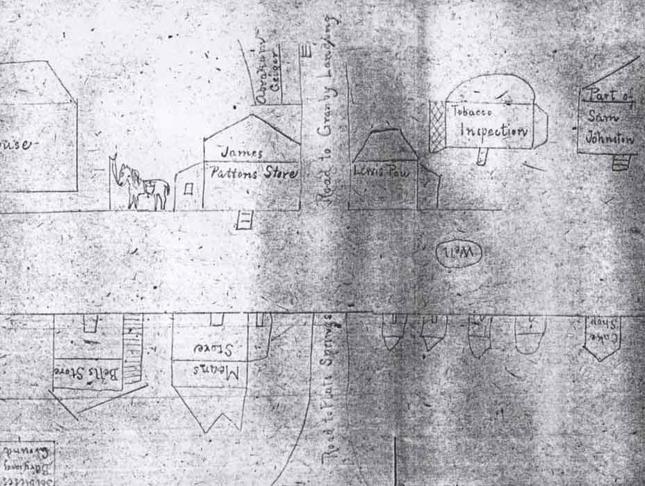
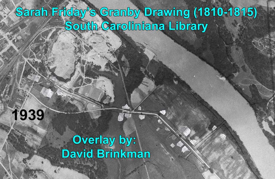
If there was a single founder of Granby, it would probably be Martin Friday whose ferry seemed to attract the development of the town. Martin also acquired much of the property that would make up Granby. It would not be until after his death, however, that the town would take on the name Granby. Martin Friday (1689-1758) would leave some of his property to his son, John Jacob Friday Sr. (1719-1779) who would pass much of it to his son, John Jacob Friday Jr. (1743-1821). This included the house that would be taken and converted to Fort Granby during the Revolution. Sarah grew up in Fridieg Entertainments house and probably spent much time in the Fort Granby House where her sister (Ann) lived with her husband, James Cayce. After the death of Ann, in 1814, James and Ann's children remained in the house and it would became known as the Cayce House. Sarah had married John Bryce in 1815 and they had one son in 1818: Senator James Edward Bryce. The 1850 will of John Bryce indicates that he was a very wealthy man and that he owned much of the old Granby land including the land James Cayce lived on. We believe that around the time of her marriage to John Bryce, Sarah created the only known drawing of Granby. The Granby dig team had been searching for this lost drawing for two years when it was finally found in the South Caroliniana Library on July 19, 2014 by John Allison. The drawing is a priceless artifact but it provides us with more information than any of the over 10,000 dig artifacts. We now have a view of the town and the names of businesses and the people that lived there. When David Brinkman applied his overlay process to Sarah's drawing, it only took a couple of extensions on the old State Road and a turn (which Sarah had marked as "Hane's Corner") to make the overlay line up exactly with a 1939 aerial photo which included several common landmarks: The Cayce House, the Mill, the Old State Road, and a lone tree at the spot where the old Court House had stood 120 years earlier. At almost 200 years later, we can now see how this old drawing falls on our 2014 aerial view. The now known location of Friday's Ferry (owned by Sarah's Great Grandfather) lines up exactly with the Ferry Road on Sarah's overlay. And there's no mistake about what our dig site is... the Home site of Sam Johnston from the 1790's until the 1820's. The large number of metal detector hits across the street from our dig property is, undoubtedly, the nails from the old Tobacco Inspection and warehouse.
We owe a lot to Sarah Friday for taking the interest and time to record this image of our lost Granby. But it also took more than just her for this to survive for 200 years. In 1905, The State newspaper printed a story about the town of Granby. The following response to this article was by a woman who had found the old drawing among dozens of insignificant documents left in a house she purchased. She recognized its historical importance and reached out to the readers of The State with the following:
The State; Date: 01-20-1905; Page: 4; Location: Columbia, South Carolina OLD GRANBY
A Former Columbian Tells of the Old Cayce Fort To the Editor of The State: This is an old Columbian, who spent the "thirties" and the "forties" in your beautiful city. I am always looking to The State to give me items of interest. Yesterday my attention was drawn to that romantic case, Bryce against Cayce. I have a map of the old town of Granby, drawn by the Miss F., whose beauty attracted Mr. John Bryce. In my childhood our plentes were held there, and my many questions to her about this place were hugely answered by this map--a rough pencil sketch representing every residence and store in the town and also the court house. I have heard persons ask was it ever a town, so this information is historic. (Mrs.) S. A. Caston, Cheraw, SC Jan 18th
As luck would have it, Mrs Caston's letter was read by a local history lover and collector. Columbia's John M. Bateman acquired the drawing from Mrs. Caston and added it to his huge collection of historical documents. In 1915, Bateman publish his book: "A Columbia Scrapbook", which included a reference to the Granby Drawing. Granby Dig team member, David Brinkman bought a copy of Bateman's book and the hunt was on. John Bateman died in 1940 but he had already made plans to donate his collection to the South Caroliniana Library. In 1942, the Library took possession and care of the Bateman collection. Although the Library's electronic index did not include the Granby drawing, Granby dig team member John Allison worked with the Library staff to locate it. As you can see, it took the care and work of multiple people and a historic institution to preserve what is probably the only surviving view of Granby. So, take a look (below) at Granby as it was 200 years ago.
On the following three overlay images, click on the image to view a larger image which is also interactive. Selecting an item from Sarah's drawing (in this larger image) will take you to another page that describes the item in detail.
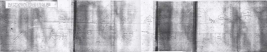
Below: Sarah Friday's Drawing from 1810-1820:
Below: Sarah Friday's Drawing on top of the 1939 Aerial photograph:
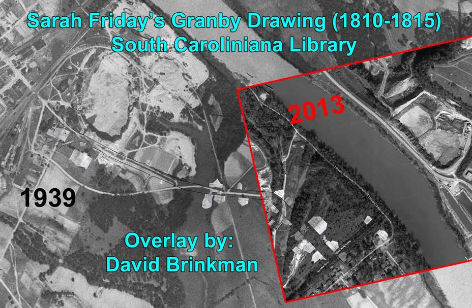
Below: Sarah Friday's Drawing on top of the 1939 Aerial photograph and 2013 Aerial of the Riverland Park area: